This lab was aimed to familiarize students with surveying various objects using a high precision GPS unit. Topographic surveying can be done in many different ways, as is evident between this surveying technique and the distance/azimuth technique conducted last week. There were seven groups of two students gathering topographic point data for roughly five features per group. I personally surveyed an emergency-call telephone, a tree, a fire hydrant, a light post, and two signs. There was one extra attribute recorded, and that was the diameter of the tree that was surveyed.
Study Area:
- Date: April 12, 2016
- Location: University of Wisconsin-Eau Claire behind the Davies and Phillips buildings (Figure 1)
- Conditions: Cloudy with some wind; temperature of 44 degrees Fahrenheit
 |
| Figure 1: Study area using the Dual-Frequency GPS unit |
Methods:
Equipment
There were four components used for surveying with the Dual-Frequency GPS unit (Figure 2). The first being the TopCon HiPer S4. This is the GPS receiver that is attached to the top of the unit. Next is the TopCon Tesla which is a screen monitor and creates files and records the data as it is taken. A UTM Zone 15N projected coordinate system was used with the features recorded in the units of meters. A MiFi portable Hotspot ensures a personal wifi hotspot wherever the unit goes. And lastly, a tripod stand kept the unit stable and allowed for the other three components to be attached to a single unit.
The class was broken down into groups of two and each group then took turns collecting point features with the GPS unit. At each location a feature was recorded. The Northing and Easting were recorded with the TopCon HiPer S4, as well as the elevation above sea level. Each time a feature or object was selected to be recorded, that feature must first be selected in a drop-down menu previously created on the GPS unit itself. At each location a feature needed to be recorded, the tripod was simply leveled and positioned as close to the feature as possible to ensure reliable positional data accuracy. Once the user is ready to take the collect the data, the button "collect" is pressed on the TopCon Tesla screen monitor. The TopCon is extremely precise, being able to tie a feature down to just millimeters of the actual location of the unit. The GPS unit collects and averages roughly 20 points after this button is pressed, so it is important not to move the unit during this process. There is also a more accurate method to collecting data, which simply collects a minimum of 60 points when collecting the data. However, for a project like this it is perfectly fine to use the quicker method which does not take quite so many points. This is because the project does not call for highly accurate or precise surveying techniques since it is only used for a teaching tutorial. The Dual-Frequency GPS unit does not need to only be used to gather data for various features. It could also be used to merely take elevation and location data of a sloping study area, for example.
 |
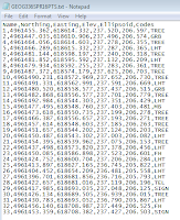
| Figure 3: Normalized text file |
able to be imported into ArcMap where it was able to be displayed as points by clicking the 'Display XY Data' button. A topographic base map was added to provide a relative backdrop of the locations of the features.
Results:
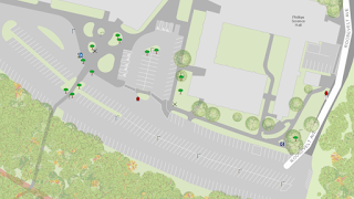
As a class, there were a total of 33 feature points collected: 14 trees, 11 lamp posts, 2 fire hydrants, 2 campus signs, 2 garbage bins, 1 emergency telephone, and 1 mailbox (Figure 4).
 |
| Figure 4: The final map created from the point features data |
Discussion:
This method of collecting topographic data with a Dual-Frequency GPS unit seemed to be rather efficient and highly accurate. However, when personally collecting data in the field there were a couple of problems. Right behind the Phillips Science Hall, the GPS unit was not able to gather points effectively. It was a 'dead zone' and the unit was not able to get a fix because there was radio interference which could be caused by electrical wires. This problem can be bypassed simply by changing the setting so the unit does not collect quite as accurate data. And if worse comes to worst, the user can simply turn off the unit and it should be able to get a fix after it is turned back on. It also appeared that the data for tree diameters were not transferred into the table so I wonder why that happened. But it would have been interesting to look at the differences in tree diameters and be able to show that on the map.
No comments:
Post a Comment